

What truly lies at the bottom of Halifax Harbour? It’s more than just water—it’s a time capsule containing everything from colonial artifacts to mid-century Volvos. Join the scientific team using cutting-edge tech to decode the mysteries and long-lost narratives hidden in the deep.
Located in the Halifax Regional Municipality of Nova Scotia, Halifax Harbour is a massive ice-free natural inlet that has served as the backbone of the city’s economy and history for centuries. Carved by ancient glacial activity and later submerged by rising tides, this deep-water port was a vital commercial hub on the Atlantic coast long before Canadian Confederation. Its history is marked by both strategic importance and tragedy, most notably in 1917 when the devastating Halifax Explosion—caused by the collision of the SS Mont-Blanc—became the largest accidental man-made blast in history. While the harbour is fed by the Sackville River and features unique geography like the Bedford Basin and the Northwest Arm, it has also faced significant environmental struggles. Following two hundred years of untreated sewage runoff, the area suffered severe pollution that forced the closure of local beaches in the 1990s. Despite the launch of the CA$400 million Harbour Solutions project at the turn of the millennium, efforts to fully restore the water quality have met with mixed results.

Long before European arrival, the Mi’kmaq First Nation inhabited this land, naming the waters Kjipuktuk, which was later anglicized to Chebucto. Geographically, the harbour follows a northwest-to-southeast orientation and occupies a premier strategic position on the Atlantic. Because it sits just an hour north of the Great Circle Route—the primary shipping lane between Europe and North America—it serves as a critical gateway, acting as the final outbound or initial inbound stop for vessels utilizing transcontinental rail links.

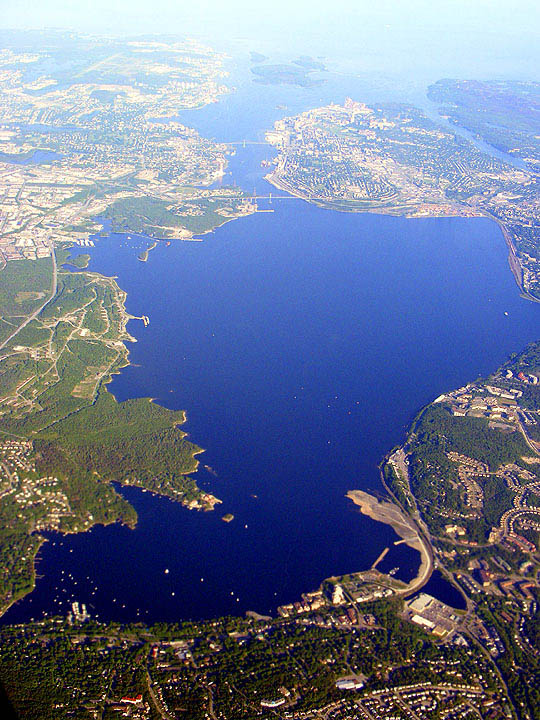
The physical structure of the harbour is essentially a prehistoric glacial valley that was submerged as sea levels rose. While the Sackville River currently flows into the Bedford Basin, its ancient, submerged riverbed has been meticulously mapped across the harbour floor and out into the ocean. The waterway is composed of several distinct sections:
- Bedford Basin: The expansive, protected bay that forms the harbour’s largest reach.
- The Narrows: A slim, strategic bottleneck connecting the outer harbour to the Basin.
- Northwest Arm: A secondary drowned valley that has evolved into a popular hub for recreational boating.
- Scattered throughout the waters of Halifax Harbour are several islands that define its geography and historical landscape. The harbor’s boundary is marked by the northern tip of McNabs Island, the largest in the area. Within the harbor limits themselves, Georges Island stands as the most prominent feature; much like Citadel Hill on the mainland, this island is a geological formation known as a drumlin. Further inland, the Bedford Basin shelters a cluster of smaller islands near the communities of Burnside and Bedford.
The harbor’s smaller landmasses also hold somber historical significance. In the Northwest Arm, Deadman’s Island serves as a final resting place for prisoners of war from the War of 1812. Nearby, Melville Island—connected to the shore by a causeway—houses the Armdale Yacht Club and borders Melville Cove, which shares its name with the surrounding neighborhood. While technically located just beyond the official harbor boundaries, Devils Island and Lawlor Island are also widely regarded as integral parts of the local maritime landscape.

Following the Canadian Confederation in 1867, civic boosters in Halifax held high expectations that federal support would transform their city into the nation’s premier winter port and a vital gateway for European trade. Geographically, the city was perfectly positioned; its location along the Great Circle route made it the closest mainland North American port to Europe. However, these natural advantages were quickly undermined by political and military logistics. The Intercolonial Railway (ICR) was constructed along a circuitous southerly route rather than a direct one, and the federal government showed a surprising lack of interest in actively promoting Halifax over international alternatives.
As a result, the city struggled to compete with American infrastructure. Despite appeals to Canadian nationalism and the ICR’s internal efforts to drive traffic eastward, the majority of Canadian exporters preferred the efficiency of rail routes leading to Boston or Portland. This lack of patronage left local promoters in a constant struggle to fund the modern, large-scale facilities the harbor desperately needed. It was not until the eve of the First World War that Halifax finally secured the necessary investment to begin constructing the massive Ocean Terminals in the city’s South End. Ultimately, it was the onset of global conflict, rather than peacetime policy, that finally elevated Halifax to its intended status as a dominant force in North Atlantic shipping.
Enjoy these The Scuba News Canada articles on Halifax Harbour
Comments