


Built at the Frank Phelps Shipyard in Chaumont, New York, in 1899, the Northern Lights was a 39-gross-ton scow schooner measuring 65 feet long, 17 feet wide, and 6 feet deep. Originally owned by Captain William Shelley Sr. of Cape Vincent, the two-masted vessel served as a vital workhorse for the regional economy. It regularly transported agricultural goods, including baled hay, choice beans, and premium peas, delivering them to local seed houses in Chaumont.
Structurally, the Northern Lights combined the attributes of a sizeable schooner with those of a traditional river scow. Her forward deck stretched back to the mainmast, flanked by broad running boards on both sides that led to the aft deck. This layout allowed the helmsman to stand at the stern and steer the vessel using a long, sweeping tiller. The crew’s living quarters, or forecastle, were situated beneath the bow deck directly ahead of the mast, reachable only by descending a ladder through a hatchway or companionway.

The vessel’s ownership eventually transferred to Dexter Dibble of Sackets Harbor, leading to its ultimate demise a few years later. In November 1916, while Dibble’s sons, Sam and Spencer, were managing the schooner and loading it with gravel at Calf Island, the boat broke free from its lines. The Northern Lights drifted and ran aground on a rocky shoal running parallel to the eastern side of Galloo Island, an area known as South Harbor. The stranded ship sat on the reef for a year until a violent storm lifted it over the shoal and into the deeper waters of the harbor, where it finally sank. Like many scows of the era, the Northern Lights was a utilitarian craft operated by working-class sailors to support local commerce—vessels so commonplace that when they were destroyed, they were quickly forgotten by history, even when tragedy claimed the entire crew.

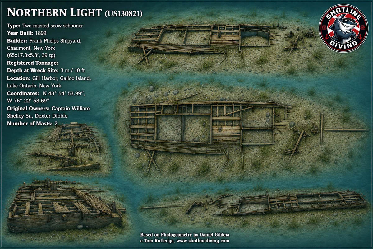
New map release of Northern Light shipwreck in Lake Ontario
We’re proud to release yet another new map — this one from the U.S. side in honour of Memorial Day.
More than just a chart, this model is a tribute to the history, sacrifice, and stories that rest beneath the surface. Crafted by SLD’s own Dan Gildea, the map combines detailed research, precision modelling, and the unmistakable passion that drives the diving and maritime history community forward.
Whether you’re a wreck enthusiast, historian, diver, educator, or simply someone who appreciates preserving the past, this release was made to be explored, shared, and enjoyed.
This work is released under the Creative Commons CC BY-NC-ND 4.0 license, meaning you are welcome to copy, print, save, and share it freely with proper credit — just please don’t sell it or modify it.
We believe history should be accessible, especially when it helps connect communities across borders and generations. Memorial Day is a fitting moment to reflect on that connection and remember those who served and sacrificed.
Download it, study it, hang it on your wall, take it to the dive boat, and share it with fellow enthusiasts. Tom Rutledge and Daniel Gildea
Comments